


LA Metro - Official
TAP LA
When I need to use Los Angeles public transportation without guessing where my train or bus is, LA Metro - Official is the app I would open first. It is a free travel and local app from TAP LA, built around trip planning and live ride information for Metro. That focus makes it more useful than a general map app when the important question is not simply “how do I get there?” but “is the service I need actually moving right now?”
I found the app most valuable when I treated it as a practical travel companion rather than a complete replacement for every navigation tool. It can help shape a route, check the current situation, and reduce the uncertainty that comes with waiting for public transportation. At the same time, it works best when I already know roughly where I am starting and where I want to go. It is not designed to be a broad city guide, a sightseeing planner, or a substitute for careful preparation on a complicated journey.
How I use LA Metro - Official for a normal trip
My baseline workflow is simple. Before leaving, I use the trip-planning function to think through the journey from the first stop to the final destination. I check the route instead of relying on memory, especially when a trip involves changing lines or combining different parts of the Metro network. This gives me a chance to notice whether the suggested journey is straightforward or whether it includes a connection that deserves extra attention.
Once I have a route in mind, I use the live information to check the ride I am actually planning to take. That second step matters. A route can look perfect in a planner while the real service is delayed, approaching later than expected, or affected by a change in conditions. The strongest part of the app is the connection between planning and tracking: I can move from “which service should I use?” to “what is happening with that service now?” without switching immediately to a different tool.
A realistic example would be an afternoon trip across Los Angeles for an appointment. I might plan the journey before leaving home, then check the relevant arrival information while walking to the station. If the live view shows that my expected ride is not arriving as I thought, I have a better chance of choosing another departure or allowing more time before I reach the platform. That does not remove every transport problem, but it replaces blind waiting with a more informed decision.
Related News

Why WhatsApp Messenger Still Makes Everyday Communication Feel Easy

Jurassic World: The Game Is the Better Dino Tycoon for Strategic Players

Threads in Real Life: Who Should Join, Lurk, or Leave

How SHEIN Turned Shopping Into an Endless Content Feed

How to Make Fortnite Feel Smarter on Mobile

Should You Switch to Microsoft Outlook on Mobile?
I also like checking the route again shortly before the return journey. The outward trip and the trip home often happen under different conditions, and assuming that the same plan will work in reverse can be a mistake. A repeat check is a small habit, but it prevents me from treating an earlier estimate as a promise. The most useful routine is plan first, verify live service second, and check again before returning.
What the app is particularly good at
LA Metro - Official is strongest for people who use Metro regularly or who are visiting Los Angeles and want information focused on the local network. Its purpose is narrower than a general navigation platform, and that narrower purpose is an advantage when I want transit details rather than a long list of driving, walking, cycling, and commercial suggestions.
The live tracking is also more useful when I use it at the right moment. Checking it hours before a trip may give me a general idea, but checking shortly before departure helps me make a real decision. I would not stare at the screen continuously while waiting. Instead, I would check once while preparing, once while approaching the station, and again if the wait becomes unexpectedly long.
Gallery
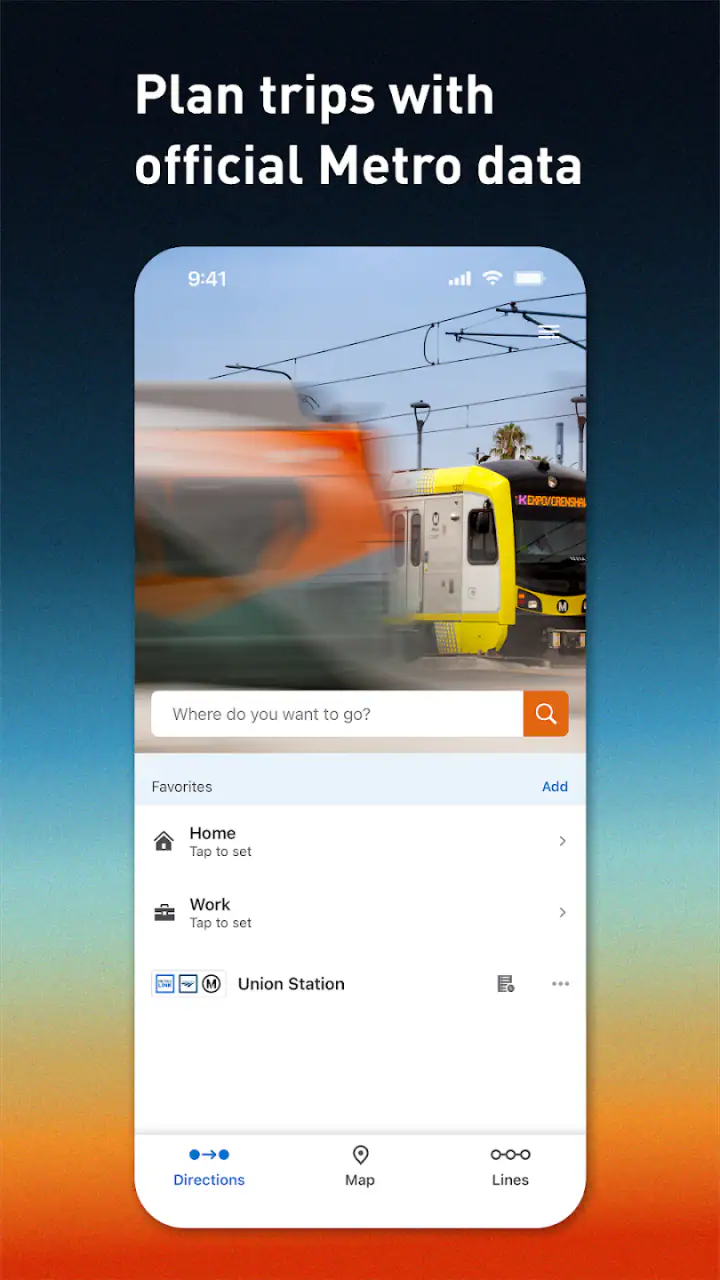
Another practical strength is that the app can become a single reference point for a Metro-focused journey. I do not have to remember every stop or depend entirely on a screenshot taken earlier. When plans change, I can return to the app and reassess the route. That makes it especially helpful for visitors who are still learning the geography of Los Angeles and for occasional riders who do not yet have reliable instincts about connections.
Settings and preparation that make the experience smoother
There is no need to turn the app into a complicated project. I would begin by checking the basic settings available on the device and inside the app, particularly anything related to location access, notifications, and data use. Location access can make trip planning more convenient when I am starting from an unfamiliar place, while notifications may be useful for people who want reminders or service-related updates when those options are available to them.
I would also make sure the app is installed and opened before I am standing at a busy station with limited time. This is less glamorous than an advanced trick, but it is one of the most effective habits. I can confirm that the interface makes sense, identify the route-planning area, and avoid trying to learn the app while a vehicle is approaching. It is worth doing the first route search from a calm location rather than during a rushed transfer.
The minimum operating system is Android 7.0, which gives the app a broad reach across older Android devices. The current version is 5.194.1.1788. I would still keep the application updated when possible, because live transport tools depend on reliable communication with current service information. An older installation may open normally, but updating is a sensible part of maintaining any app that I use for time-sensitive travel.
For a visitor, I would prepare two or three likely destinations before leaving accommodation. That does not mean building an elaborate itinerary. It simply means knowing the name of the destination, the approximate starting point, and the journey I expect to take. With that information ready, the app becomes a decision tool instead of a place where I am trying to solve every detail from scratch.
One useful trade-off is location convenience versus control. Allowing the app to use my location can reduce typing and help when I do not know the nearest station. Entering locations manually can be preferable when I am planning for somebody else, checking a future departure from a different area, or comparing two starting points. I would choose the method that matches the trip rather than leaving every setting on automatically.
Faster patterns for repeat riders
Experienced users can save time by following the same sequence every time. I would first identify the destination, then check the suggested Metro route, then inspect the live status of the specific service that matters most. This order keeps me from getting distracted by information that does not affect the immediate decision. If the first part of the journey is a short walk, for example, the critical detail may be the train or bus connection that comes afterward.
For a familiar commute, I would avoid rebuilding the entire mental process from zero. I can remember the usual route while still using the app to verify current arrival information. That combination is faster than asking the planner to teach me a journey I already understand, but safer than relying on memory alone. The app then acts as a live check layered over an established routine.
Another efficient pattern is to check the next important connection rather than only the first vehicle. If I am already on the way to a station, the first departure may not be the only thing that matters. A delayed first leg can affect a transfer, and a route that looks acceptable at the beginning may become inconvenient later. Looking ahead to the connection helps me judge whether changing plans now is better than discovering the problem halfway through the trip.
I would also use the app differently depending on whether I am early or late. When I have plenty of time, I can compare route options and choose the one that feels easier. When I am already behind schedule, I need a quick answer: which service should I take, where should I board, and what live information changes that choice? The app is more helpful when I decide in advance which question I am asking instead of browsing without a clear purpose.
For group travel, one person can plan while another confirms the live ride details, but I would still share the actual route in plain language. Transit apps are not a substitute for agreeing on a meeting point. If a group separates during a transfer, everyone should know the intended station or destination rather than assuming the app will solve communication problems. This is a small but important limitation of any individual travel tool.
Where it differs from general map apps
Compared with a general map application, this app feels more focused on Metro itself. A broad map tool may be better when I am comparing public transit with walking, driving, or rideshare options, or when I need business information and turn-by-turn directions around the final destination. LA Metro - Official makes more sense when the central question is the condition and timing of a Metro ride.
That focus also means I would not use it as my only travel application for every Los Angeles outing. If the last part of the route involves a long walk through an unfamiliar neighborhood, I may still want a mapping tool for street-level guidance. If I am deciding whether public transportation is practical compared with another mode, a general planner may present a wider comparison. The official app is better at its own lane than at trying to cover every travel possibility.
There is a trust benefit in using an official Metro-focused application for Metro information, but I would not interpret that as a guarantee that every journey will be effortless. Live information can help me react to conditions; it cannot make a delayed vehicle arrive sooner or remove the need to understand a transfer. I still leave a little flexibility for crowded platforms, walking time, and the possibility that my real journey takes longer than the screen suggests.
Limits that matter on difficult journeys
The app is not the right choice for somebody who wants a full travel planner for an entire vacation. It is also less suitable for users who rarely use public transportation and prefer a single map that explains every mode in one place. The focused design is useful for Metro riders, but that same focus can feel restrictive when the journey includes services or decisions outside the Metro network.
I would be cautious about treating real-time information as exact. The store summary emphasizes accurate, live ride information, and that is valuable, but transport timing is still something I use to guide decisions rather than make absolute promises. I would not schedule a critical appointment with no buffer simply because the app displays an expected arrival. For an important event, I would plan an earlier departure and use the live view to monitor the trip.
There can also be friction when I am using the app in a hurry. A person unfamiliar with Metro terminology may need a moment to understand the route and identify the relevant line or stop. That is why I recommend preparing the destination before leaving and checking the interface in advance. The app can reduce uncertainty, but it cannot replace basic orientation or careful reading.
Another limitation is behavioral rather than technical: constantly refreshing the live screen can create more anxiety than clarity. I get better results by checking at meaningful points in the journey. If nothing important has changed, repeated checking does not improve the plan. A disciplined routine makes the information more useful and keeps the app from becoming a distraction.
Who should install it
I would recommend it to regular Metro riders, occasional visitors, students, workers with appointments, and anyone who wants a Metro-centered way to plan and monitor a trip. It is especially worthwhile for people who have experienced the frustration of arriving at a stop based on an old assumption and then discovering that the expected ride is not behaving normally.
It is also a sensible companion for visitors who do not want to depend entirely on a general-purpose map. The app can help them understand the transit portion of a route, while another navigation tool can handle the surrounding walking directions if needed. That combination is more realistic than expecting one application to be perfect for every stage of a Los Angeles journey.
I would suggest skipping it as the main travel tool if most of your movement is by car, if you need extensive sightseeing recommendations, or if you want one interface that compares every transportation option. In those cases, a broader navigation service may fit better. The choice depends less on whether the app is good in the abstract and more on whether Metro is central to the trips you actually make.
My final view after using it as a travel habit
LA Metro - Official does not try to be a universal city companion, and I think that is the reason it can be useful. It gives Metro planning and live ride checks a clear place in my travel routine. I use it before leaving, verify the important service near departure, and check again before a return trip or connection. That workflow is simple enough for occasional riders and efficient enough for people who use the network often.
The app is free, rated for Everyone, and has built a solid audience, with an average rating of 4.5 from around 164 ratings and more than 10 thousand installs. Those figures suggest that it is established enough to be worth trying, but I would still judge it by my own travel needs rather than by popularity alone. The developer is TAP LA, and the app belongs firmly in the Travel & Local category.
My honest recommendation is to install it if Metro is part of your real routine, especially when live arrival information affects whether you leave now, wait, or change your route. Use it alongside a general map when you need broader walking or city guidance, and keep a time buffer for important journeys. For Metro-focused travel, its best feature is not simply route planning; it is the repeatable habit of checking the plan against what is happening right now.
FAQs for LA Metro - Official
What is LA Metro - Official, and what can I use it for?
LA Metro - Official is the official mobile companion for Los Angeles County’s Metro transit system. After exploring its main tools, I found it useful for checking rail and bus routes, viewing schedules, locating nearby stations and stops, and planning journeys across the network. It is designed for everyday commuters, occasional visitors, and anyone trying to navigate Los Angeles without relying entirely on a car.
Does LA Metro - Official provide real-time arrival and service information?
The app is intended to provide current transit information, including scheduled departures and, where available, real-time arrival predictions. It can also help users check service alerts, planned changes, and disruptions affecting Metro lines. However, arrival estimates may change because of traffic, vehicle delays, technical issues, or incomplete data, so it is wise to confirm important trips and allow extra travel time.
Can I use LA Metro - Official to plan trips involving buses and trains?
Yes. One of the app’s most useful functions is trip planning across Metro bus and rail services. You can enter a starting point and destination to review route options, transfers, walking sections, and estimated travel times. Before downloading, remember that results may depend on your location settings and the latest transit data, and some journeys may involve other regional transportation providers.
Does LA Metro - Official support fares, passes, or TAP card services?
LA Metro - Official may provide information related to fares, passes, and the TAP payment system, helping riders understand ticket options and how to pay for Metro travel. Depending on the version and your location, certain account or mobile-ticket features may require signing in, compatible device settings, or an internet connection. Check the current app listing for the exact payment features available on Android or iOS.
Does LA Metro - Official work without an internet connection?
The application is most effective when connected to the internet because route planning, service alerts, live arrivals, and updated schedules can change throughout the day. Some previously loaded information may remain temporarily accessible, but you should not depend on full offline functionality for an important journey. For better results, enable location services when needed and check your route before entering areas with weak reception.
Pros
- Official real-time arrivals
- alerts
- and service updates
- Trip planning covers buses
- trains
- and transfers
- Supports TAP card balance and fare management
- Station information includes accessibility details
- Useful maps help navigate the entire Metro network
Cons
- Real-time data can be delayed during disruptions
- Some features require a stable mobile connection
- TAP functions may vary by card or device
- Interface can feel crowded for first-time riders
- Limited usefulness outside Los Angeles County


